Added new firmware (and BLM) with the following new features:
– Depending on setting by the event director disallow multiple marker drops of the same number during flight.
– On startup in case old goal declarations or marker drops are found, ask the pilot if it is a new flight.
– If the logger is set to use GPS altitude, don’t ask QNH.
The software and firmware can be downloaded in the Official’s section
BLM 2.1.181
Fixed a problem with marker drops in the western or southern hemisphere.
The software can be downloaded in the Official’s section
Switch off/on issue resolved!
I am very glad to announce that after many nights of debugging I could finally fix the nasty switch off/on issue! The issue caused loggers to crash during switch off in random cases. They couldn’t be switched on until batteries had been removed. I know that some pilots experienced stressful situations if the issue occurred.
I just published the new firmware release 1.2.178 which contains the fix and also a few cosmetic improvements.
I would like to thank the guys from Flytec for their support in resolving the issue.
We have 90 devices! Ready for the Europeans!
Since Mid July we have 90 loggers in the pool! This is enough devices to run the Europeans this year in Lleida. But already before the loggers are required for many competitions in Europe including German Nationals, British Nationals and the Spanish Nationals.
New Firmware 1.2.172 and BLM 2.1.174
I just published the latest Firmware and BLM software. It is almost one year since the last official release, but we did a lot of work since… I just didn’t find time to publish the latest versions.
The big improvement is the introduced flexibility in coordinate transformation. We can now support use many map datums and grid systems. But also BLM has completely been redesigned and improved.
BLM 2.1.174
BLM is completely rewritten and also renamed to just BLM! It is now even much stronger, supports the same coordinate systems as the logger and can export data to WPT, PLT, GPX and Excel. See a full description at its separate page.
Firmware 1.2.172
New major firmware version 1.2:
– Added map datum and grid system support. Datum Support is dependant on the BLM software version. The following Grid Systems are supported:: Lat/Long, UTM, Custom Transverse Mercator, British National Grid, Swiss Grid
– Improved battery handling
– Use RTC to have correct date/time before GPS fix
It also contains the following fixes:
– Fixed minor issue with rounding of instrument error
– Fix problem with wrong date being shown as the first fix date at some conditions
– Fixed communication for flash dump
– Added hardware support for the latest hardware generation (2011 built devices)
No track on the SD-Card? There is still hope!
If the SD-Card is lost, not readable, or if no IGC files can be found on the card, there is still hope! The logger stores all tracks in its internal flash memory. The memory has space for at least 5h (@1s interval). Old data is automatically overwritten.
To download the track from the logger use the BLM.
- Start the logger. Press Ok
- Do not enter QNH. As soon as QNH is entered, the logger starts recording and might override the track that you are just looking for.
- Connect the logger to the PC.
- In BLM select “Logger”–>”Download Track”. Follow the instructions on the screen.
Online Logger Tutorial
We are very pleased to announce an online logger training website, developed by Mathijs Debruijn.
You are able to try all functionalities of the logger and familiarize with it’s operation. The tutorial also gives you a lot of good information and guidance on how to act and react with the logger. If you have never used the logger and are planning to participate in an event run with these loggers, please give it a try.
The link is http://www.balloonloggers.org/tutorial and can also be found in the menu on the right.
Charging the loggers
The loggers have rechargeable batteries. Each logger comes with a power charger. Please follow the following rules.
- Only official chargers may be used!
- Never replace the batteries with other types
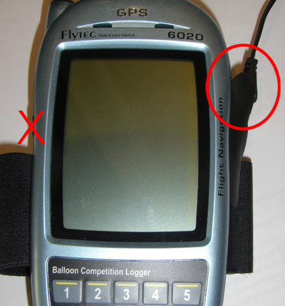
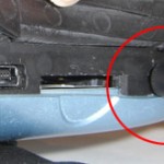
- Make sure you connect the right plug in the logger (see pictures)
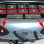
- The lights on the bottom of the logger will turn on (constant or blink). Keep the logger charging until both lights switch off
Especially take care to use the correct plug, the charger plug fits into two holes of the logger!

New firmware 1.0.126
– Added Swiss Grid system
– Corrected instrument error behaviour
– Adjusted GPS timeout
– Fixed minor GPS parsing problem
– Improved device shutdown (but switch on has now to be blocked for 5 seconds after switch off)
Attention:
Upgrading to this firmware removes all stored tracks on the loggers with firmware prior to 1.0.115.
Converting tracks using GPSBabel
GPSBabel is a free software tool that can be used to convert different track file formats. It can be downloaded from gpsbabel.org.
Convert to different file formats
The following command converts a logger igc file into a OziExplorer plt file. Please note, that 2 files are written. output.plt is the file with barometric altitude while output-1.plt uses GPS (above MSL) altitude.
gpsbabel -t -i igc -f -o ozi -F output.plt
The above example generated OziExplorer plt files. GPSBabel supports many track file formats.
| Format | -o parameter | |
| OziExplorer | ozi | |
| Garmin PCX5 | pcx | |
| GPX XML | gpx | |
| MemoryMap | mmo |
A list of all supported formats is listed on the GPSBabel homepage.
QNH correction
The logger stores the barometric altitude with QNH=1013.25. In order to adjust for the real altitude the barometric altitude must be corrected using the following formula:

This can also be done with GPSBabel:
gpsbabel -t -i ozi -f output.plt -x height,add=[dalt] -o ozi -F output-2.plt
with [dalt] beeing delta alt as calculated in the first line of the formula above. Of course the above line can be called with different file formats as well.


